The hill of Montbelleux is a small elevated feature in the Marches de Bretagne, situated on the territory of Luitré-Dompierre approximately ten kilometres south of Fougères. The deposit is described by geological sources as a stanniferous-wolframiferous district of exceptional character, composed essentially of Brioverian schists approximately 540 million years old, bounded to the north by the cadomian granodioritic massif of Fougères and to the south by the Palaeozoic terrains of the medioarmorican synclinorium. The gisement is a vein and stockwork type tungsten deposit 650 metres long, divided into two principal veins: one of quartz-wolframite in schists, comprising five layers, exploited before 1958; the other of cassiterite-wolframite in greisened granite, exploited from 1978 to 1983. The principal minerals extracted were wolframite (tungsten ore) and cassiterite (tin ore), with minor quantities of topaz and gold.
Tin had been extracted on the hill from the Bronze Age. The rediscovery of the modern deposit is attributed to Fernand Kerforne, professor of geology, in 1903. The concession of wolfram, tin, copper, and associated metals of Montbelleux was instituted by decree of 1 May 1905 and covered 482 hectares across the communes of Luitré and Parcé. The concession was held by Robert Surcouf, Fernand Kerforne, and François Collet-Pintiaux, with exploitation granted to the Société Minière de Montbelleux under the direction of M. Bayle.
The first period of research, from 1903 to 1906, employed two master-miners and eighty workers on the puits Collet-Pintiaux through to the puits Surcouf. The first period of extraction began on 15 May 1907, when a mineral preparation plant known as the lavoir à minerai was brought into operation, equipped with a Schlamms table which processed 591 tonnes of raw ore. The workforce reached 204 workers, of whom 118 worked underground. From 10 October 1908, works were suspended in consequence of a fall in tungsten prices.
The second period of exploitation, from 1910 to 1911, was conducted by the société en nom collectif Gruzard-Clolus et Courtois under the direction of M. Bayle, employing an average of 120 workers. The third period, from 1916 to 1918, was served by three shafts. By 1918 the average daily extraction was 41 tonnes of raw ore yielding 221 kg of wolframite. A fire at the lavoir halted all extraction in 1918.
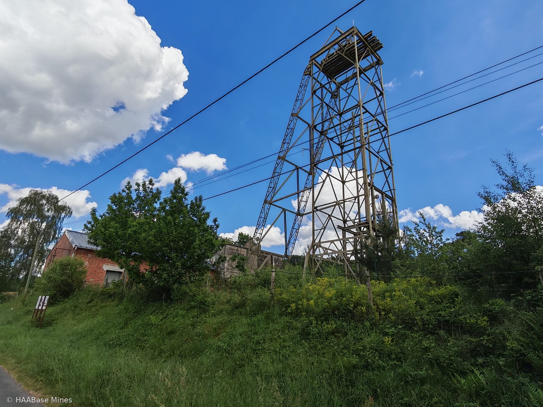
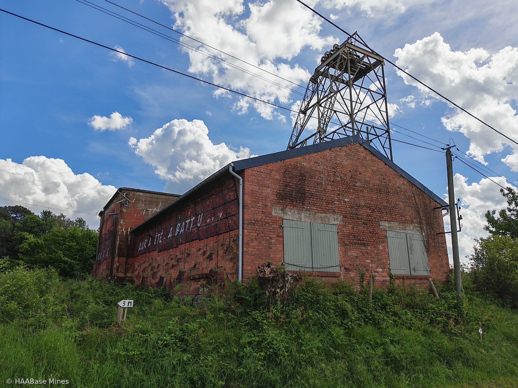
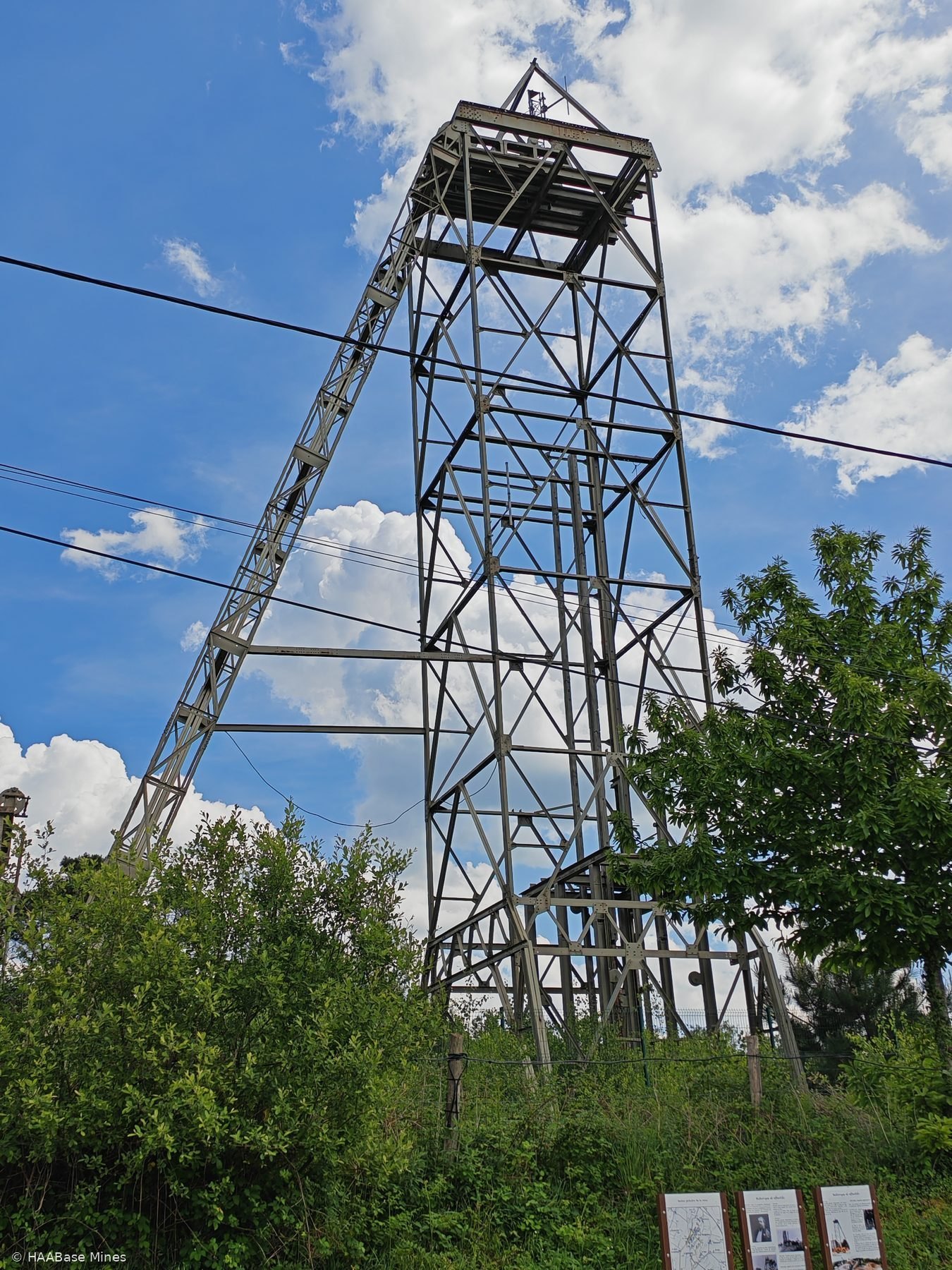
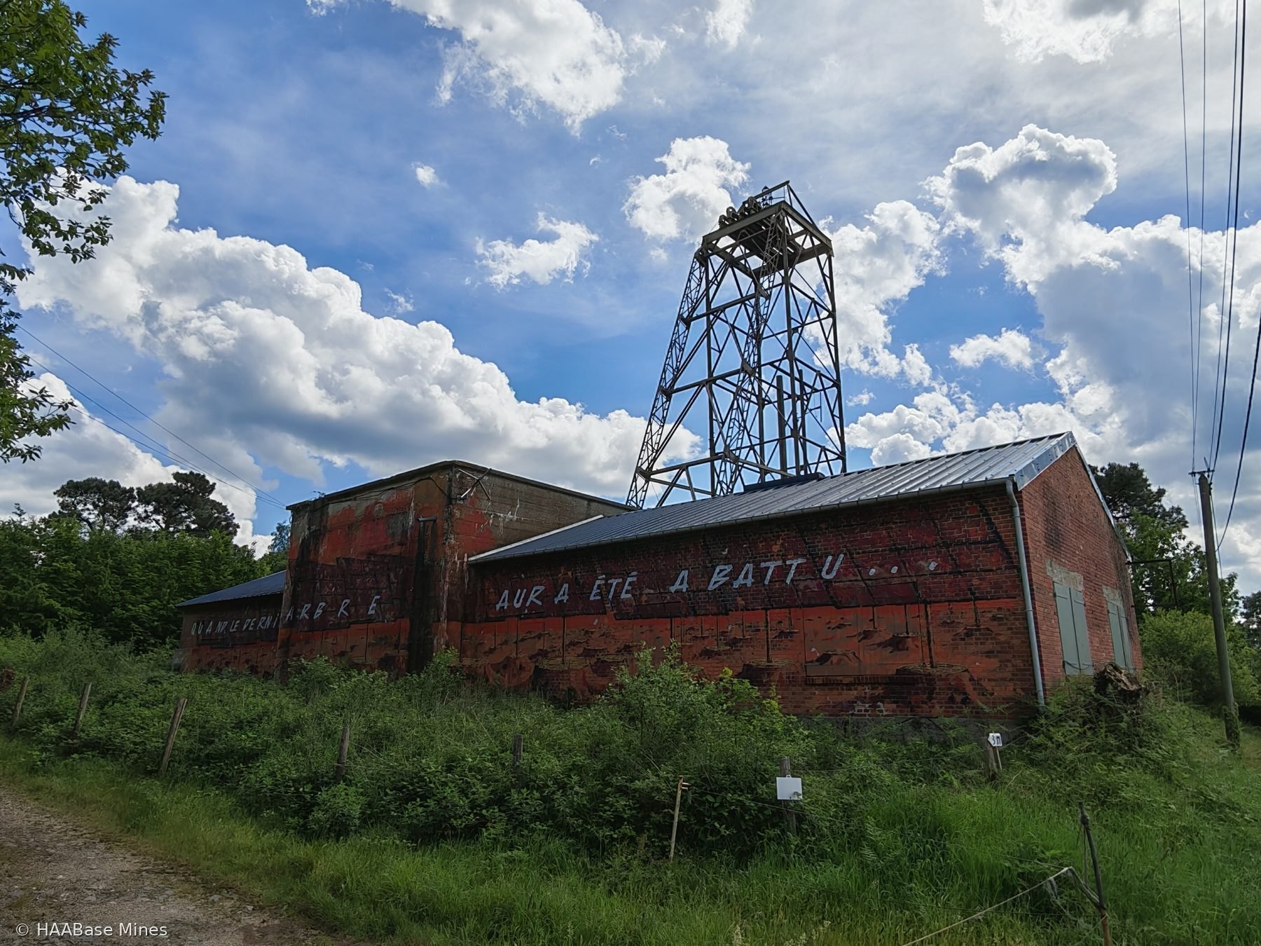
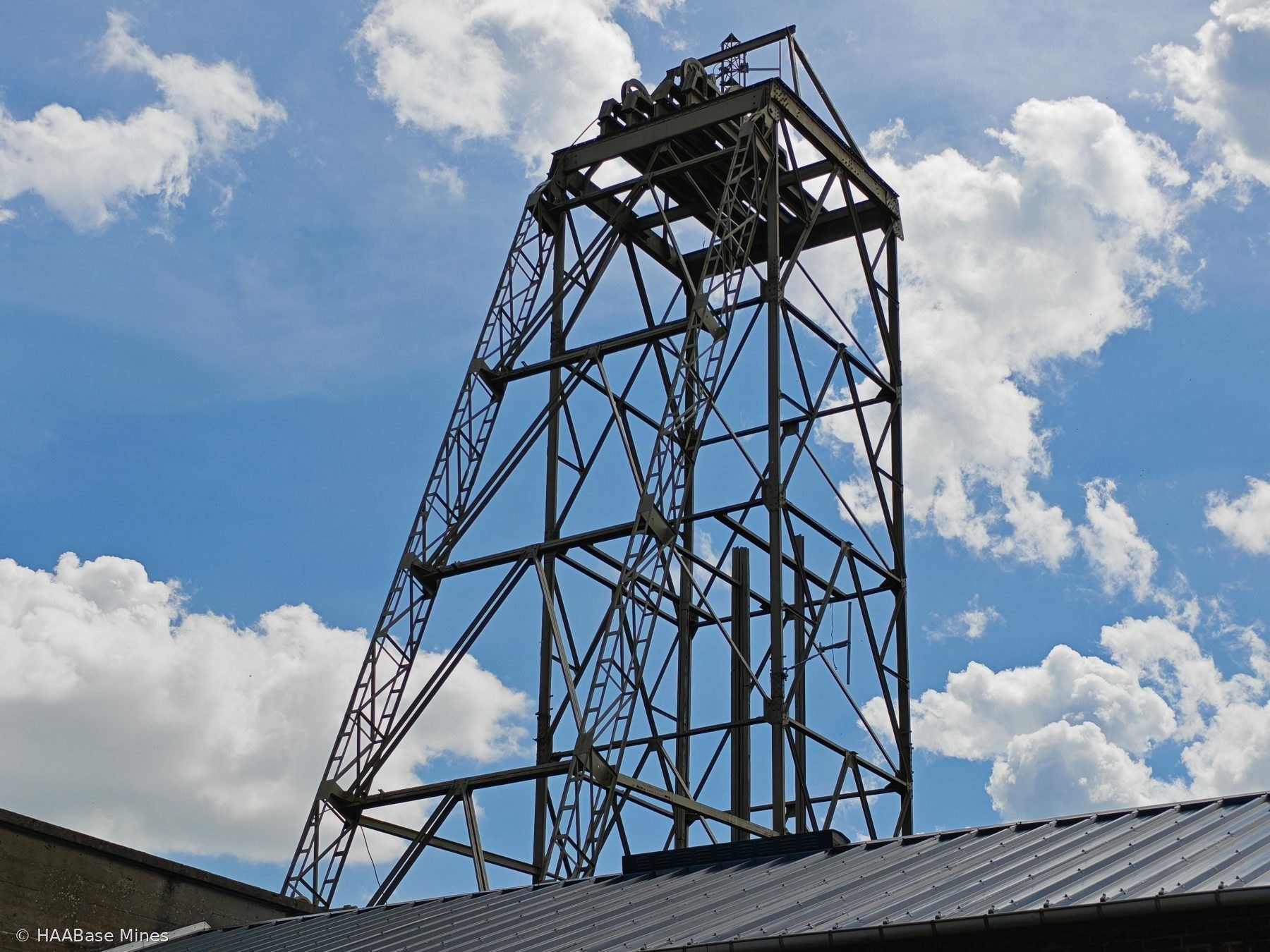
By July 1936 the Société Minière de Montbelleux was placed in receivership. On 12 June 1937 the concession was remitted for exploitation and sold to Edgar Brandt, with the mutation of the concession formally recorded on 7 April 1938. The fourth period of exploitation, from 1942 to 1944, was initiated under German occupation. A headframe was erected over the puits Surcouf on 10 September 1942. In October 1942 the workforce stood at approximately 300 persons, of whom around 30 were German, rising to approximately 550 at peak. A railway line connecting the pit yard to the gare de La Selle-en-Luitré was laid and a connection to the high-tension electricity network established. This fourth period ended in 1944 by sabotage accompanying the departure of the German forces, followed by a period of pillaging.
In 1948 to 1950 the local mining authority pressed the concessionaire to recommence exploitation. Following the reinstatement of certain buildings in 1951 and dewatering of the shafts in 1952, the fifth period of exploitation began effectively in 1954 with the construction of a new pre-concentration lavoir. The works were entrusted to the société des Mines de Puy-les-Vignes from 1948 to 1950. The workforce during this period stood at 140 persons, of whom 84 worked underground. From 1957, the Société des Mines de Montbelleux moved towards reduced activity owing to insufficient production and falling tungsten prices, a situation which persisted until the revalorisation of the commodity in 1972.
A sixth and final period of exploitation commenced from 1977. From 1976, surface boreholes were sunk to investigate the granite-greisen body at depth. From 1977 to 1980, a new phase of exploration included dewatering of the old workings, restoration of infrastructure, and numerous boreholes. From 1980 to 1983, a descent road (descenderie) was excavated and served the levels at 60, 95, and 130 metres depth. A gravimetric processing plant of 40 tonnes per hour capacity was installed in 1980. In November 1982 the workforce comprised 58 persons: 5 in direction and administration, 30 miners and plant operators underground, and 23 at surface. Extraction ceased definitively on 9 August 1983 owing to underground collapses caused by the unsuitability of the exploitation method.
In 2006 the Société des Mines de Montbelleux initiated the formal procedure for the cessation of mining works. In 1995, the BRGM conducted an evaluation of public safety risks at the site. Three shafts — the puits allemand, the puits Collet, and the puits Surcouf — are recorded as having been backfilled, while the puits Neuf was unbackfilled as of 1995. In 2005 the entire 17-hectare site was classified BASIAS (polluted or degraded land) by the BRGM, with recorded contamination by heavy metals and risks of mining subsidence. A photovoltaic development proposal for the degraded land has been advanced. The headframe erected on the puits Surcouf remains standing on the hill of Montbelleux, visible from a considerable distance. The site is currently managed for heritage and educational purposes by the association Mémoire de la Mine de Montbelleux (3M), which maintains a walking circuit of 4.5 kilometres with interpretive panels. The Inventaire Général du Patrimoine Culturel identifies the Montbelleux headframe as the last surviving mine headframe in Ille-et-Vilaine.